


6-11")
“Beg your pardon?” I said.
“Self-rescue,” repeated the Chisos Basin park ranger.
“Self …”

“Yes,” the ranger continued. “Are you taking some sandboards?”
My buddy D. and I were planning on trying Big Bend National Park’s infamous River Road the following day, one of the most primitive, remote, unpredictable routes in Texas. Over 50 miles of rolling gravel and shifting sand that runs roughly parallel to the mighty — or once mighty — Rio Grande. It requires a four-wheel-drive, high-clearance vehicle, and we were advised to take plenty of water and food. And, as of that moment, we were instructed to be prepared to “self-rescue.”
In the recent past, on the challenging, desolate hikes or climbs in practically any national park, intrepid types were usually advised to inform park personnel before prospective attempts in case something went wrong. Then, if attempting hikers, climbers, or, in this case, drivers, didn’t return, park rangers would know to look for them. I was fairly sure it had been a common practice in the past, and this new policy (new to me, anyway) certainly gave me pause.
“Call a relative,” the ranger said. “Tell them what you’re doing and where you’re headed. Let them know. Tell them when you’re planning on leaving, what time you plan on being back, and that you’ll call. And if you don’t call, they can call us.”
“What’s a sandboard?” I said.
Turned out, I knew what a sandboard — or a variation thereof — was. I’d been in several scrapes and near-scrapes traveling around Texas, and I’d actually used a “sandboard” before. While I was researching the Porvenir Massacre several clicks back, I’d gotten a two-wheel-drive truck stuck in some red sand out in far West Texas. I’d actually slid a wooden hiking staff as far as I could under one of my back tires, and that had provided enough traction for me to self-rescue, i.e., get the truck back on the main road. It probably kept me from being stuck there overnight.
The park ranger continued. “There are a few spots where the sand down there near the river or near gulleys can get pretty deep. Four-wheel drive helps, but sometimes boards provide that little bit of extra traction. You should be fine.”
Should.
I shared what I’d learned with D.
Of all the big-ticket heavy hitters that Big Bend National Park offers, navigation of the entire River Road — east and west — was the only one I’d never attempted. And I hadn’t planned on trying it this trip. Two days before, we’d kayaked 5 miles of the Rio. It was my first time back on it since my youth, when my father took my brother and me down 170 miles of it in a canoe. Heck, on the way in from Presidio, D. and I’d even stopped off FM 170 to visit “Dom” of Fandango fame — which is still arguably one of Kevin Costner’s best movies and definitely his best performance based in Texas. D. and I had even braved the perilous perch that Costner ascended — 1,500 feet above the Rio — to dispose of “Dom” (no spoilers) after his legendary toast: “Here’s to us and what we were … and what we’ll be.”
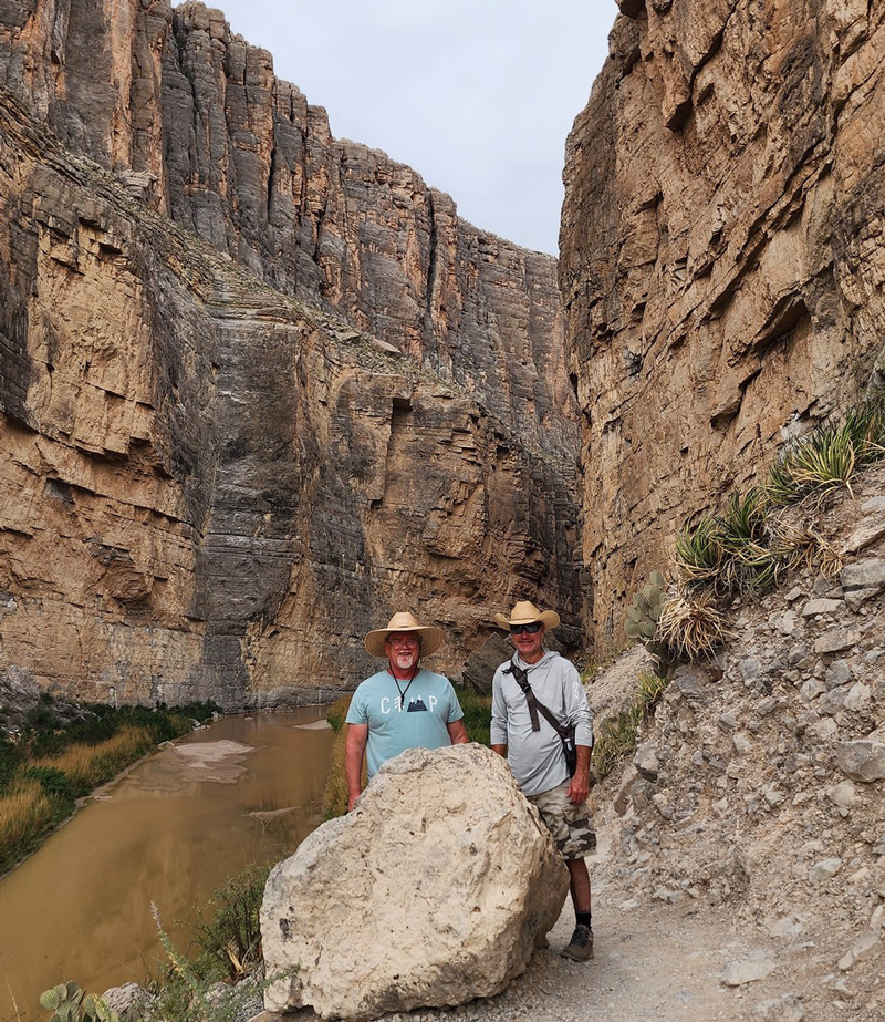
Photo by E.R. Bills
And there we were, 150 stories up, being. Not anxiety-ridden by the pusillanimous hail of trumped-up politicos, paralyzed by waking and relentless existential dread, inert at the current ladder rung we’d ascended to via ruthless obsequiousness or prudent wage slavery, or superficially sedated by mindless streaming binges. For a moment or so, we were actually inspired, alive, challenged. Adventurous, even. And all that away from conditioned air and our favorite recliners.
When I contacted my next of kin to let them know about our River Road trek, they said some of the pictures they were seeing on social media didn’t look fun at all — that they were concerned. And they emphasized that if our plans to navigate the River Road would make us susceptible to any problems, dangers, or other general hazards, then “please don’t go!”
“You know we’ll be careful,” I replied.
And we were.
We had packed food, water, and plenty of ice. We found some discarded 2-by-6 wooden planks to serve as sandboards from a construction site in Terlingua. We carried up-to-date first-aid packs, water purification tablets, and anti-venom kits. We topped off the truck’s gas tank. We had a good spare tire and a functioning jack. We took precautions and prepared accordingly. The only thing we couldn’t do anything about was a cell phone signal. The fiftysomething-mile excursion would have to be made without phone access. If something went sideways, we would be on our own.
Hence, self-rescue.
We might be able to seek assistance from other campers or River Road runners if we encountered any. It might be possible to flag down a Border Patrol agent if we encountered one. We might stumble onto immigrants. If our truck got stuck, broke down, or rolled, we might be forced to hike out. We considered the pros and cons carefully, but the hook was already set.
We were both wide awake at 5:30 the next morning. We splashed some water on our faces, grabbed the incidentals, then loaded everything up.
Did I mention that Big Bend National Park (established in 1935) is composed of 1,252 square miles of land, which makes it larger than the state of Rhode Island?
If I didn’t, I have now, and I probably don’t need to explain that getting from any one point to another wasn’t a matter of city blocks or even a crosstown jaunt. Nothing was close to anything. So, though we left the Chisos Basin at 6:15 a.m., we didn’t make it to the turn-off for the East River Road, just north of the park’s Rio Grande Village camping area, until 7 a.m.
The first mile or two of the River Road was simply bumpy gravel through the lowland Chichuahuan Desert. Then, the rugged terrain began to twist and rise, then straighten only long enough to drop or tail off unexpectedly. Limestone hills and sandstone outcrops loomed in every direction, tempered by mesquite trees, Spanish daggers, lechuguilla, pricklypear, blind pricklypear, fluffgrass, and creosotebush. And after only a few miles in, we saw another vehicle coming our way.
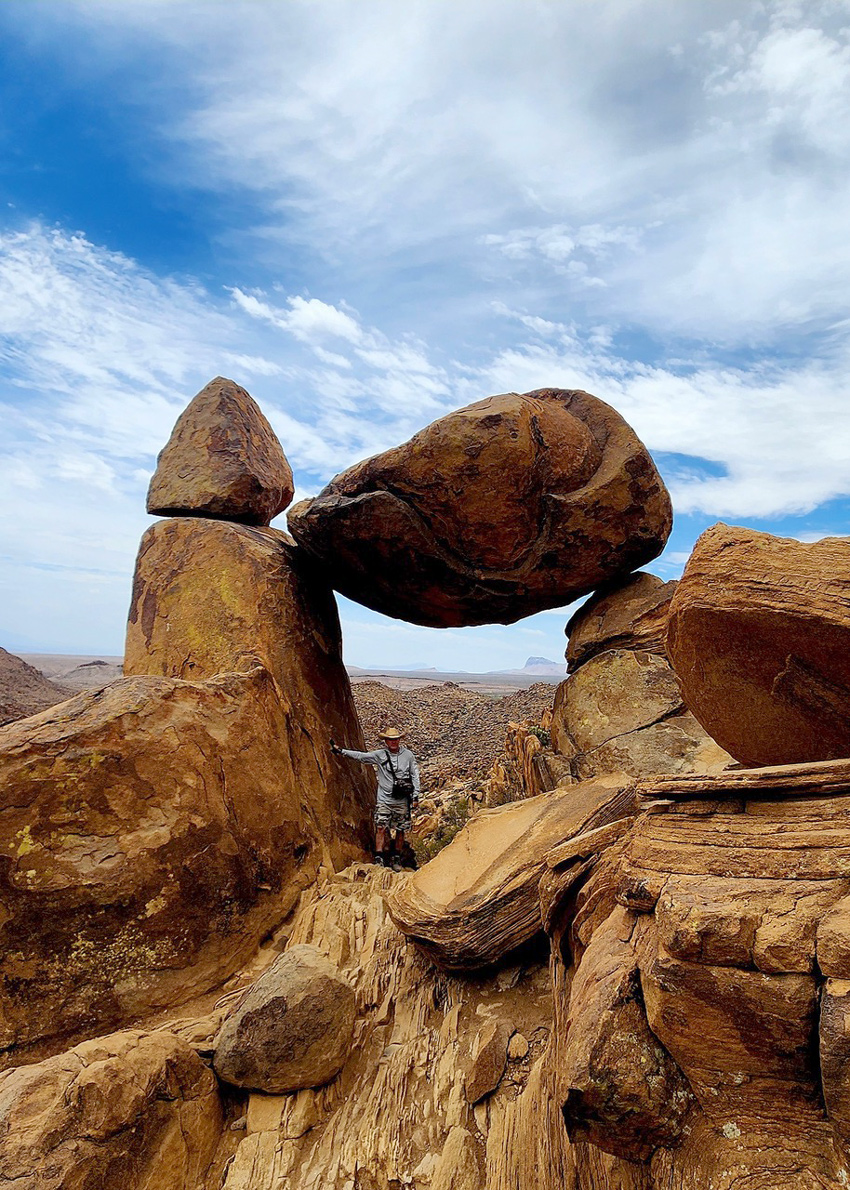
Photo by E.R. Bills
“Border Patrol,” D. observed, pulling over, anticipating inspection, but the vehicle had already pulled off in the distance. We drove on up and stopped alongside. It was no big deal. We chatted for a moment, discussed the route ahead, then pressed on.
Just past Gravel Pit Road, which led to a put-in on the Rio, we slowly navigated our first, rough, braided streambed.
Roadrunners darted out in front of and away from our approach. Pocket gophers gave us a wide berth. There are actually pink snakes (western coachwhips) that eat rattlesnakes in this part of world, but we never saw any. We did see the occasional jackrabbit, but no javelina.
By the time we passed a spur that led to the La Clocha primitive campsites, we started to see the abandoned rock and adobe ruins of San Vicente, Texas, famous only for a couple of stops that the U.S. Camel Corps are said to have made near there in the 1850s. But our attention quickly shifted to its twin community, San Vicente, Mexico, where Presidio San Vicente was established by the Spanish in 1723. Now a small farming village, it sprawls for miles on the other side of the Rio Grande.
From there, we gingerly crossed a major sand wash that provides drainage down to the Rio after rainfall. Evidence of large, dry gulleys and waterborne sand suggested recent flooding, and we put the truck in 4WD and treaded carefully. Chilicotal Mountain rose over 4,100 feet to the northwest, and, though it was slow going, we soon spotted the northeasterly Glenn Spring Road turn-off. It was the audible we planned to call if the going was too rough or we were worried about going the whole way — our Plan B abort option. We passed it and kept moving.
The flat-topped 3,700-foot Talley Mountain soon appeared off to the northwest, then the imposing 1-mile-wide, 9-mile-long Mariscal Mountain rose southwest. Meanwhile, the River Road was now steep hills, low washes, and sprinkles of soaptree yucca, chino grass, and purple pricklypear here and there. The draws that cut across the River Road changed after every heavy rain, but it had been dry for a while. The sand could be dicey, but at least there wasn’t any mud.
A road to the Solis primitive campsites (named after a family farm that occupied the area in the early 20th century) appeared to our left, and we took it, hoping to drive right up to the edge of the Rio. But the last half-mile was potentially treacherous sand, so we doubled back. The exit afforded us the only glimpse of another human being we would see outside their vehicle for the rest of the journey. Two, in fact, and they were camping at the first primitive site on Solis Road. I think we gave them a wave, but I can’t remember for sure. And then we were back on the main River Road, heading west, plodding slowly, minding the gulleys and navigating the climbs and drops carefully, probably averaging 2 to 3 miles an hour along many stretches.
The road never completely disappeared, but it often seemed to drift and sometimes sink in the sandier spots. Soon, we were approaching the Fresno primitive campsite to the north, then the incredible, deceivingly picturesque Mariscal Mine, just southwest. The Mariscal Mine Historic District was composed of more than 60 historically registered frame, rock, stucco, and dugout structures, several along the main road. The primary structures in the distance appeared to be in great shape. We took a short drive to a small visitor’s area and simply marveled at the ruins. The hull and remains of an engine block from a Great Depression-era automobile begged a photo op, and, a mile or so away, we could see the main framework of the old mine, which was constructed to retrieve cinnabar, from which mercury was extracted. Posted signage warns explorers to stay off and out of the remaining structures because they are fragile and hazardous and may contain poisonous concentrations of mercury.
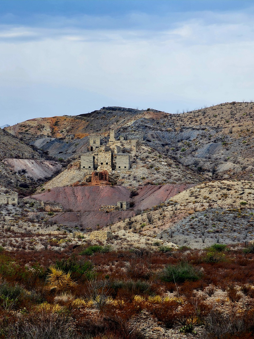
Photo by E.R. Bills
D. and I were both interested in hiking up to the mine proper and maybe checking out the mine shafts and more, but we still had the rest of the River Road to contend with. And we knew we hadn’t even traveled halfway — yet.
By the time we reached the midway point, we thought we were making good time, but the west side of the River Road was much more topographically challenging than the east. In many places, our progress slowed to a crawl or came to a standstill as we surveyed the way forward. The grades grew steeper, and we navigated one-lane-only hairpin curves and abrupt, draw-terraced descents. We trudged on cautiously, slowing past the Dominguez primitive campsite (north of the road) and skipping the short, southwest detour to the Loop Camp primitive campsites.
Roughly 5,180 to 7,820 feet above sea level, the Chisos Mountains dominated the northern horizon. And soon, though we never seemed more than a half-mile from the Rio, we didn’t see it. Lowlands or river cane obstructed the view, and more than once I bemoaned forgetting to bring my machete. But any Indiana Jones path-hacking would have been ill-advised.
We did sneak south to have a look at the remains of the Johnson Ranch (and its related primitive campsites), but we found only front stoop steps to an old, floorless foundation and a long-defunct wellhead. The stretch from there to the Black Dike primitive campsite seemed to be the longest interval of the entire journey. The rolling, twisting terrain kept us at a prudent snail’s pace, straddling gulley-wash crevices and sandy draws. White sand, red sand, brown sand — then gravel, flat river rocks, and volcanic boulders and ancient, eroding igneous formations.
Black buzzards circled, and the temperature rose. It was too late to turn back, especially since we had begun to feel confident about making it. Triangulation Station Mountain rose 3,143 feet to the north, and that view was soon eclipsed by something we recognized: the backside of the Mule Ears Peaks formation.
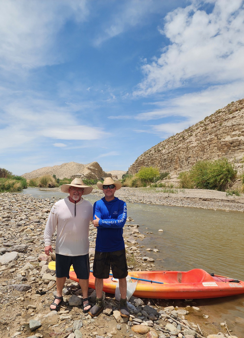
Photo by E.R. Bills
A paved Ross Maxwell Scenic Drive right turn would mark the end of our trek down the River Road, and for several miles, we thought we were coming up on it or that it would be around the next bend or over the next rise. Just past the Black Dike primitive campsite, the rocky road actually granted us a view of Rio Grande, greenish in that spot, and we stopped for pics and a breather.
From there, the road frequently consisted of dry creek bottoms weaving through rocky hills, winding, curling, rising, falling. At about six hours in, we skipped the southwesterly turn-off for the Buenos Aires primitive campsite and kept rolling. A profile glance of the Mule Ears Peaks formation came into view, and, due west, a faraway notch in Mexico’s limestone-plateaued Mesa de Anguila revealed the opening to Santa Elena Canyon, which we hiked the day before.
In retrospect, our ascent to the pavement that signified our return to civilization (in that part of the world, at least) was somewhat anticlimactic. We had begun to enjoy the respite the journey afforded us. Almost immediately, the term “self-rescue” took on new meaning.
The drive wasn’t over — we still had to travel back across the park from west to east on paved road, but we detoured north and had a late lunch in Terlingua.
Signals restored, our phones pinged, toned, vibrated. We were back on the grid. We could be reached again, traced, tracked, monitored. All the comforts of connectivity via the virtual umbilical cord of AT&T, Verizon, all the rest.
I phoned my “self-rescue” next-of-kin contact and let them know a search would be unnecessary, that we’d made it. We grabbed a quick meal, then headed back up to the Chisos Basin.
Now, that we’re back, I’ve thought a lot about the phrase “self-rescue.” I like it.
And not only do I like it. I recommend it.
I’m always good for a road trip and enjoy getting away, but Big Bend National Park and its infamous River Road are something different. The park features no sterilized natural landscapes for puttering around in a golf shirt and skinny slacks, and the closest you come to a Starbucks or a fruit smoothy is carefully extracting cactus water from a denuded pricklypear if you’re desperate. (It’s actually an excellent source of water content and electrolytes.) You’re isolated, stuck with yourself and whatever hardy companions have joined you. In many places and situations, you’re working without a net (pardon the pun). No 911. No timely medevac transport. You’re disconnected and unplugged but somehow arguably more connected than ever.
After our Border Patrol visit, we didn’t see another functioning vehicle until just before we returned to pavement. Yes, it was a little unnerving, but the risk was worth the reward because the reward was a revelation.
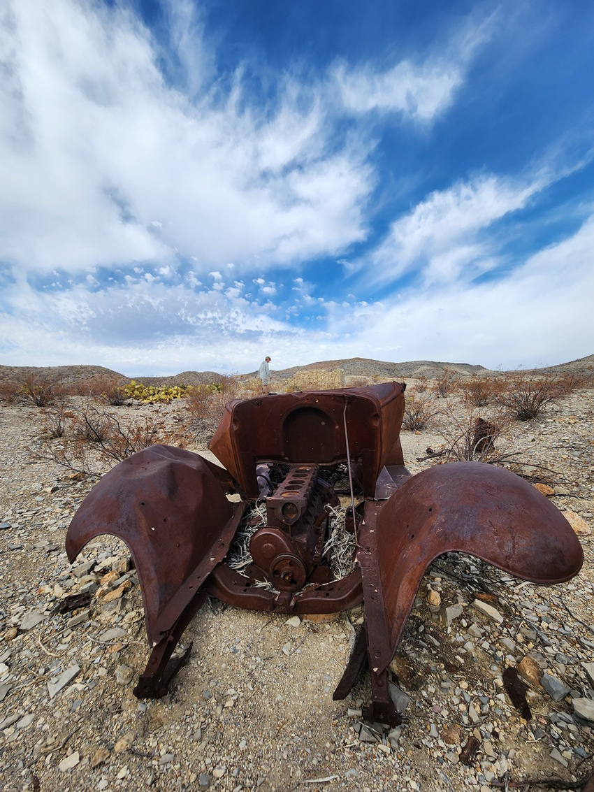
Photo by E.R. Bills
We think we’re too busy for a break and too often resign ourselves to the diversion and escape of electronica and virtual experiences instead of pursuing the real thing. We seem more comfortable being disconnected from being than really being. And we’re more partial to watching actors or reality TV stars do it than doing it ourselves.
It doesn’t have to be as far out as Big Bend. Caprock Canyons State Park, Copper Breaks State Park, South Llano River State Park, and Caddo Lake State Park are only 3-4 hours away for most of us, and there are dozens of “self-rescue” destinations all around and in between. Why wait?
Fort Worth native E.R. Bills is the author of 100 Things to Do in Texas Before You Die.


