Few if any Fort Worthians who survived the 2021 snowpocalypse will fail to jolt to attention on hearing the phrase “winter storm.” And there’s ample cause for concern about the 2026 edition now enveloping much of the country, including our slice of the globe.
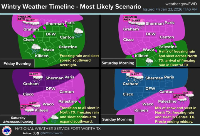
Winter Storm Fern pairs single-digit low temperatures with plenty of precipitation. Much moisture will land as ice, making driving hazardous if not foolhardy. Ice will shroud power lines and tree limbs and likely cause power outages. Those will be localized if Texas electric generator operators learned their 2021 lessons. If not, outages could be widespread.
Fortunately, Fern appears less intense and less long-lasting than Uri five years ago. We’ll see just one day of heavy precipitation and three days of constant freezing temperatures. After dropping below 32 Friday night and starting Saturday at 26, temps will reach just 28 before plummeting to 14. Sunday will dawn at 20 degrees and tumble to a record-setting 6 degrees overnight. Monday will peak at 27 before falling to 8 that night. Little if any ice will melt before Tuesday’s sunny high of 40, and for several days, nighttime lows will remain below freezing.
Forecasts give a 100% chance of precipitation all day Saturday. Up to a tenth of an inch of ice and an inch of sleet could accumulate early. Later, expect an inch of snow and sleet, along with another tenth of an inch of ice. Sunday has a 30% chance of snow, ending at noon, but 30-mph gusts mean sub-zero wind chill. Monday brings sunshine and calm winds if continued bitter cold. Stay home if you can until roadways clear. All week, keep pets warm. Check on neighbors and vulnerable people and be wary of carbon monoxide poisoning from fireplaces and generators.


