Two dozen river authorities plus other entities like regional water districts manage much of Texas’ surface-water resources. The Brazos authority, created in 1929, oversees that river from near Lubbock to its mouth near Freeport. The authority manages and sells water from Lake Granbury, Possum Kingdom Lake, and Lake Limestone (located on the Navasota River). Like other river agencies in the state, it finances its operations through selling water and hydroelectric power.
The authority supplies water to cities, towns, and water utilities along the way (Round Rock, north of Austin, is one of its largest municipal customers), to the Comanche Peak plant, to farmers and other irrigation customers, and to industries, including oil and gas drillers who use it for hydraulic fracturing and related activities.

Matthew Phillips, government customer-relations manager at the Brazos agency, said he understands Granbury residents’ frustrations, but he reiterated that Lake Granbury and Possum Kingdom were built primarily as water-supply lakes. People and businesses all along the river, not just in Granbury, depend on that water for basic needs.
The recreational activities of folks who have lakeside homes come second to fulfilling water-supply needs, he said. And while “pump[ing] up the economy” of the region is also one of the authority’s missions, Granbury’s isn’t the only economy to be considered, Phillips said.
In an application filed with TCEQ in 2004, the river authority asked to be allowed to take another 400,000 acre-feet of water beyond its current 600,000 acre-feet to sell to current and future customers like the dozens of new residential neighborhoods appearing across the Brazos River basin. To understand how much water that is, if the million acre-feet were contained in a cube, it would be nearly 40 miles on a side.
“The major issue is not what’s being taken out,” said Phillips, “but rather what has not been flowing in from the watershed above for the last three years.” The river agency filed the application “because the Brazos River Authority’s job is to supply water and to secure future water resources,” he said in an e-mail. Taking more water from the river is the cheapest and most efficient way to supply water needs in the Brazos basin, he said, compared to taking privately owned land to build another reservoir, which is what the state’s water plan calls a “secondary strategy” to provide water.
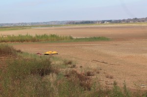
Records show that between 2010 and 2012, the inflow rate to the Brazos basin has been less than one-third of that in the previous worst three-year period, during the drought of record in the 1950s.
Recently, the Possum Kingdom Lake Association hired a hydrologist to evaluate the flow of the Brazos as it enters Possum Kingdom; he concluded the river was down 30 percent from the previous Brazos River Authority-commissioned study.
Managing water has become a balancing act for most river authorities as the drought and population growth threaten the rivers’ water levels.
Phillips said the river authority could pull water from the entire Brazos basin, not just a couple of lakes, to make up the additional 400,000 acre-feet. The authority has permits to take water from another eight reservoirs controlled by the Army Corps of Engineers, he said. “They own the cup, and when we need water, we ask them to tip it.”
********
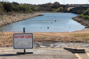
Gary Newton spends time most mornings on his back porch, overlooking Lake Granbury. And almost every morning, there is less lake to look over. The smell of dead fish hovers like a cloud. He used to fish often on the lake, but now his boat spends more time in storage than on the water.

Created in 1969, Lake Granbury sparked a major growth period for the historic town with its iconic courthouse square. The lake has always been shallow, no more than about 10 feet at its deepest point. On a map, it resembles more of a Chinese dragon crawling across the ground than a canyon filled with water like Possum Kingdom. Now, with the river authority requesting additional water rights, residents in Granbury are mad, and they’re getting organized.
“The Brazos River Authority is taking the most water from the smallest lake with the highest economic value and the largest population,” wrote Granbury City Manager Wayne McKethan, on the website of an activist group called Save Lake Granbury.
But Newton knows the problem is more complex than just the river authority’s management of lake levels. That conclusion was reinforced when he ran into a United States Geological Survey crew surveying on the side of Highway 51 just north of town. The crew told him that discrepancies between their flow calculations for the Brazos and actual readings had brought them to the Granbury area seeking an explanation.
Downstream from Granbury, where the riverbed changes from clay to gravel, the waters of the Brazos seep into the ground to help recharge the Trinity Aquifer, one of the most extensive and heavily used groundwater resources in Texas, providing well water for several counties across North Texas, including Tarrant, Parker, and Montague.
The Trinity Aquifer is also one of the slowest charging aquifers in the state, and the USGS crew told Newton they’re studying how the recharge process works because the aquifer isn’t recharging like it should be.
“The Brazos River Authority can overcommit [on sales of river water],” Newton explained. “And when the water falls out of the bottom of the Brazos River, it’s a major problem. They must account for the loss of water going into the Trinity Aquifer.”
Tim Raines, acting deputy director for data at the USGS, said, “For this study, we’re trying to determine the magnitude of loss to the river by studying the flow volume between Granbury and Glen Rose.”
********


